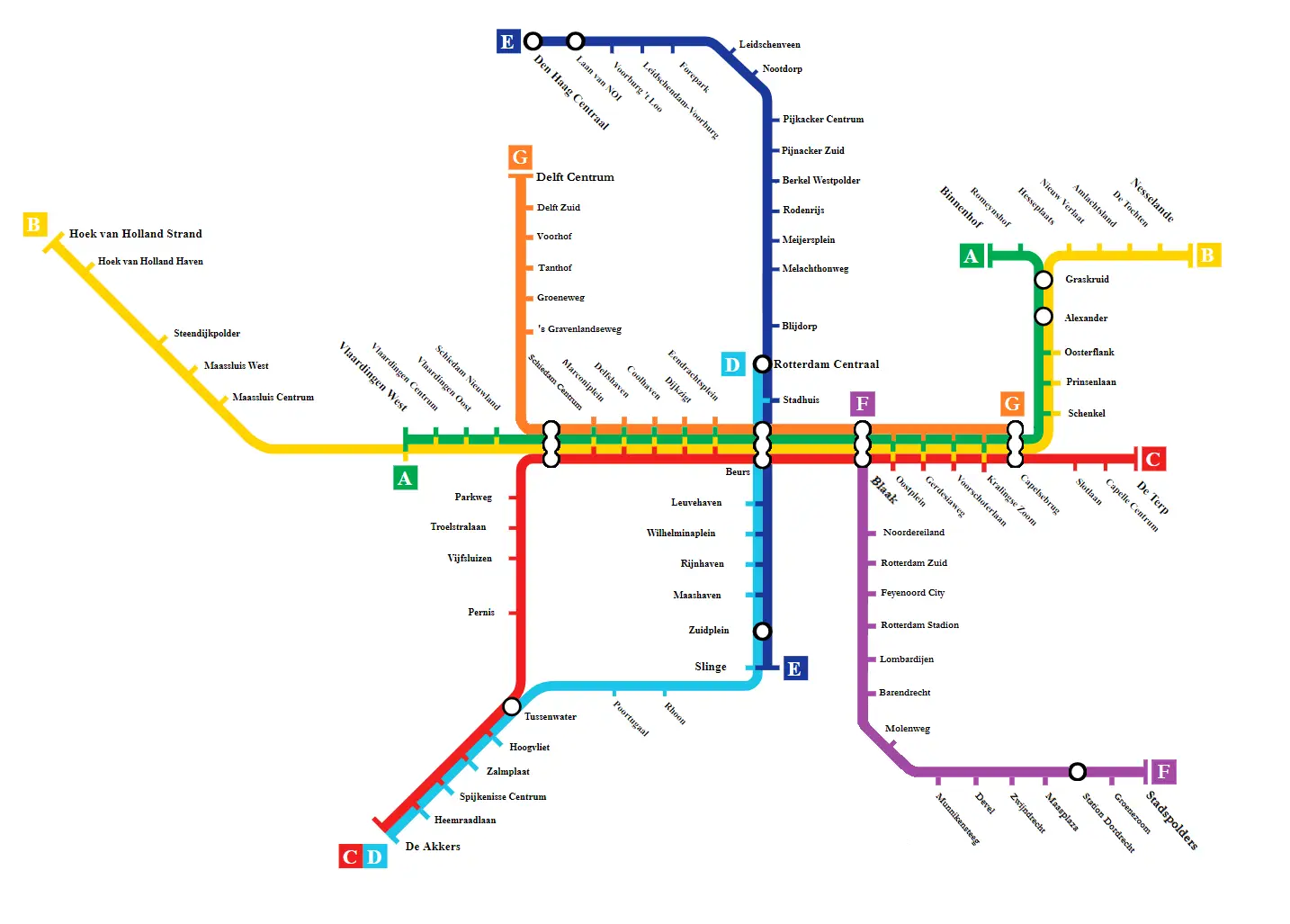
More information about the Rotterdam Metro
The Rotterdam metro network consists of 5 rail lines, spanning over 100 km and served by 160 trains that stop at more than 70 stations.
The metro operates from 5:45 am to midnight and a half, with train frequencies and schedules varying slightly between lines.
Rotterdam Metro tickets can be purchased individually or by card.
- €3.50 for a single journey lasting less than 2 hours
- €8 for a day pass
- €13.50 for a tourist ticket valid all day and on all public transport
Tourist sites to visit with the Rotterdam Metro network
Rotterdam offers numerous places to visit, and I'll show you some accessible quickly by metro.
- Sonneveld House
- Accessible via Lines A, B, and C at Eendrachtsplein station, Sonneveld House showcases how the influence of new architectural trends has been received by the upper middle class.
- Kijk-Kubus
- Accessible via Lines A, B, and C at Blaak station, The Cube Houses, innovative cube-shaped architecture, built in the 1970s.
- Markthal
- Accessible via Lines A, B, and C at Blaak station, Rotterdam's Markthal is a covered market, surrounded by buildings housing residences.
- Vroesenpark
- Accessible via Line E, stop at Blijdorp station, Vroesenpark is a landscaped park with shaded paths, tennis courts, a cafe, and food truck festivals.
Below, I present to you the 5 lines of the Rotterdam Metro
Line A
Rotterdam Metro Line A connects Binnenhof metro station to Vlaardingen West station. This line has 24 stops, covering a track length of over 23 km.
Liste des stations de la ligneA
- Binnenhof
- Romeynshof
- Graskruid
- Alexander
- Oosterflank
- Prinsenlaan
- Schenkel
- Capelsebrug
- Kralingse Zoom
- Voorschoterlaan
- Gerdesiaweg
- Oostplein
- Blaak
- Beurs
- Eendrachtsplein
- Dijkzigt
- Coolhaven
- Delfshaven
- Marconiplein
- Schiedam Centrum
- Schiedam Nieuwland
- Vlaardingen Oost
- Vlaardingen Centrum
- Vlaardingen West
Line B
Rotterdam Metro Line B connects Nesselande metro station to Hoek van Holland-Haven stop. This line has 24 stops, covering a track length of over 20 km. Line B follows Line A for a significant portion.
Liste des stations de la ligneB
- Nesselande
- De Tochten
- Ambachtsland
- Nieuw Verlaat
- Hesseplaats
- Graskruid
- Alexander
- Oosterflank
- Prinsenlaan
- Schenkel
- Capelsebrug
- Kralingse Zoom
- Voorschoterlaan
- Gerdesiaweg
- Oostplein
- Blaak
- Beurs
- Eendrachtsplein
- Dijkzigt
- Coolhaven
- Delfshaven
- Marconiplein
- Schiedam-Centrum
- Schiedam Nieuwland
- Vlaardingen-Oost
- Vlaardingen-Centrum
- Vlaardingen-West
- Maassluis-Centrum
- Maassluis-West
- Steendijkpolder
- Hoek van Holland-Haven
Line C
Rotterdam Metro Line C connects De Terp metro station to De Akkers stop. This line has 26 stops, covering a track length of over 30 km.
Liste des stations de la ligneC
- De Terp
- Capelle-Centrum
- Slotlaan
- Capelsebrug
- Kralingse Zoom
- Voorschoterlaan
- Gerdesiaweg
- Oostplein
- Blaak
- Beurs
- Eendrachtsplein
- Dijkzigt
- Coolhaven
- Delfshaven
- Marconiplein
- Schiedam-Centrum
- Parkweg
- Troelstralaan
- Vijfsluizen
- Pernis
- Tussenwater
- Hoogvliet
- Zalmplaat
- Spijkenisse-Centrum
- Heemraadlaan
- De Akkers
Line D
Rotterdam Metro Line D connects Rotterdam Central station to De Akkers stop. This line has 17 metro stops, covering a track length of over 21 km.
Liste des stations de la ligneD
- Rotterdam-Centraal
- Stadhuis
- Beurs
- Leuvehaven
- Wilhelminaplein
- Rijnhaven
- Maashaven
- Zuidplein
- Slinge
- Rhoon
- Poortugaal
- Tussenwater
- Hoogvliet
- Zalmplaat
- Spijkenisse Centrum
- Heemraadlaan
- De Akkers
Line E
Rotterdam Metro Line E connects The Hague Central station to Slinge stop. This line has 23 metro stops, covering a track length of over 27 km.
Liste des stations de la ligneE
- La Haye-Centrale
- Laan van NOI
- Voorburg-'t Loo
- Leidschendam-Voorburg
- Forepark
- Leidschenveen
- Nootdorp
- Pijnacker-Centre
- Pijnacker-Sud
- Berkel-Westpolder
- Rodenrijs
- Meijersplein
- Melanchtonweg
- Blijdorp
- Rotterdam-Centrale
- Stadhuis
- Beurs
- Leuvehaven
- Wilhelminaplein
- Rijnhaven
- Maashaven
- Zuidplein
- Slinge
Easily travel by subway to Rotterdam
The subway, short for "metropolitan railway," is a form of urban public transportation that allows you to travel through different metropolitan areas around the world without driving. No more endless traffic jams during rush hour. Taking public transportation or taking the subway has become very easy today. La carte de métro est téléchargeable ou accessible en ligne. The subway ticket can be purchased at the counter or with your phone. The price of tickets is more affordable than a taxi and more environmentally friendly.
