Lille subway map is a diagram showing the lines and stations of the Lille Ⓜ subway. They run through the beautiful city of Lille and make it easy to reach the most famous buildings in the city. The subway lines are identified by distinct colors for better legibility of your route. Some lines allow you to connect to other forms of public transportation such as trams or buses. There's nothing like visiting the city of Lille without being stuck in traffic. Less polluting, less tiring, opt for the subway and other public transportation. It is now an essential means of transportation for travel in a large city like Lille.
The Lille Metro, managed by the Ilévia company, consists of two metro lines, with over 143 automated metro cars covering 45 km of tracks. Inaugurated in 1983, it is the world's first automated metro.
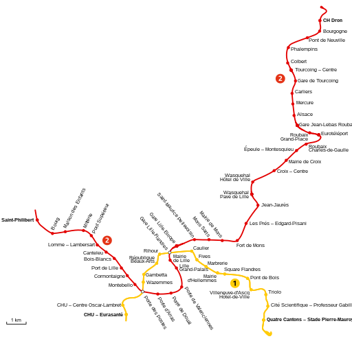
There are several intersections between the two metro lines, as well as with other public transport modes such as tram or bus.
The operating hours of the Lille metro extend from 5:12 AM to 12:30 AM on weekdays. On Saturdays, the service closes at 1:30 AM. More details can be found on the Ilevia website.
There are different fare options for the transport ticket. You can have preferential rates based on your age (4-18 years, 4-25 years, 65 and older). There is also a rate based on your family quotient CAF. Numerous offers (be careful not to get lost) are available for groups, combined with other means of transport (bus, metro, tram, and TER). The general metro ticket fare is as follows:
€1.70 one-way trip
€14.90 for 10 trips
€53 per month for an annual subscription
€61 for a single month
€5.10 for a day pass
Line 1
It connects Villeneuve-d'Ascq and Lille from the "Quatre Cantons" station to "Stade Pierre" station. Lille Metro Line 1 stretches over 12.5 km of tracks with 18 stops. There are connections to join the public transport network between Line 1, Line 2 of the metro, but also with the tramway or the Lille station.
Liste des stations de la ligne1
4 Cantons
Cité scientifique
Triolo
Villeneuve-d'Ascq
Pont de Bois
Square Flandres
Mairie d'Hellemmes
Marbrerie
Fives
Caulier
Gare Lille-Flandres
Rihour
République
Gambetta
Wazemmes
Porte des Postes
CHU - Centre Oscar-Lambret
CHU - Eurasanté
Line 2
It connects many cities in the Lille metropolitan area, from the "Saint-Philibert" station to the terminus "CH Dron". Metro Line 2 stretches over more than 31 km of tracks with 44 stops.
Liste des stations de la ligne2
Saint-Philibert
Bourg
Maison des Enfants
Mitterie
Pont Supérieur
Lomme - Lambersart
Canteleu
Bois Blancs
Port de Lille
Cormontaigne
Montebello
Porte des Postes
Porte d'Arras
Porte de Douai
Porte de Valenciennes
Lille Grand Palais
Mairie de Lille
Gare Lille-Flandres
Gare Lille-Europe
Saint-Maurice Pellevoisin
Mons Sarts
Mairie de Mons
Fort de Mons
Les Prés - Edgard-Pisani
Jean-Jaurès
Wasquehal - Pavé de Lille
Wasquehal - Hôtel de Ville
Croix - Centre
Mairie de Croix
Épeule - Montesquieu
Roubaix - Charles-de-Gaulle
Eurotéléport
Roubaix - Grand-Place
Gare Jean-Lebas Roubaix
Alsace
Mercure
Carliers
Gare de Tourcoing
Tourcoing - Centre
Colbert
Phalempins
Pont de Neuville
Bourgogne
CH Dron
Easily travel by subway to Lille
The subway, short for "metropolitan railway," is a form of urban public transportation that allows you to travel through different metropolitan areas around the world without driving. No more endless traffic jams during rush hour. Taking public transportation or taking the subway has become very easy today. La carte de métro est téléchargeable ou accessible en ligne. The subway ticket can be purchased at the counter or with your phone. The price of tickets is more affordable than a taxi and more environmentally friendly.