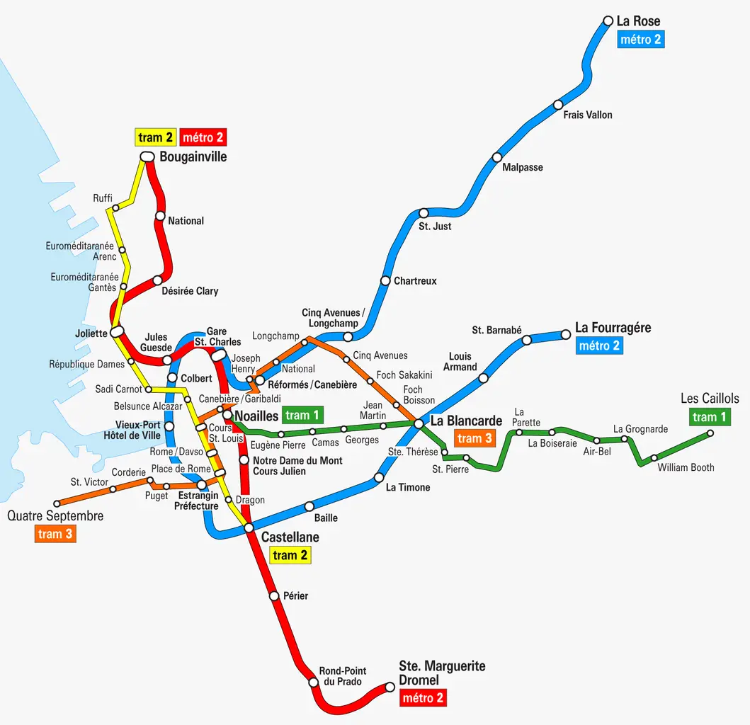
More Information about the Marseille Metro
The Marseille Metro, operated by the RTM company, comprises 2 metro lines spanning over 21 km of tracks. Inaugurated at the beginning of the last century in 1977.
Marseille Metro operates from 5 am to 1 am, with nearly continuous service on weekends.
Tickets can be purchased at the tram and metro ticket machines as well as at many sales points. The fare for your transport ticket varies:
- €1.5 for 1 trip.
- €3 for 2 trips.
- €13.40 for 10 trips.
- €5.20 for a 24-hour pass.
- €10.80 for a 72-hour pass.
There are also subscriptions for longer durations; you can inquire with the RTM.
Quick access to all Metro lines:
Line M1
Marseille Metro Line M1 was the first in the city. It connects 18 stations over 12.7 km.
It takes you from La Rose station in the northeast of the city to La Fourragère in the east of Marseille. You can stop at the Old Port, on La Canebière, or near your favorite restaurants. Feel free to get a map of Marseille.
List of Line M1 stations
- La Rose
- Frais Vallon
- Malpassé
- Saint-Just
- Chartreux
- Cinq Avenues
- Réformés – Canebière
- Saint-Charles
- Colbert
- Vieux-Port Hôtel de Ville
- Estrangin
- Castellane
- Baille
- La Timone
- La Blancarde
- Louis Armand
- Saint-Barnabé
- La Fourragère
Line M2
Marseille Metro Line M2, created in 1984, connects 12 stations over 8 km of tracks.
It takes you from Bougainville station in the north of the city to Sainte-Marguerite-Dromel in the south of Marseille. Saint-Charles metro station allows you to reach the bus station.
List of Line M2 stations
- Bougainville
- National
- Désirée Clary
- Joliette
- Jules Guesde
- Saint-Charles
- Noailles
- Notre-Dame du Mont
- Castellane
- Périer
- Rond-Point du Prado
- Sainte-Marguerite-Dromel
Easily travel by subway to Marseille
The subway, short for "metropolitan railway," is a form of urban public transportation that allows you to travel through different metropolitan areas around the world without driving. No more endless traffic jams during rush hour. Taking public transportation or taking the subway has become very easy today. La carte de métro est téléchargeable ou accessible en ligne. The subway ticket can be purchased at the counter or with your phone. The price of tickets is more affordable than a taxi and more environmentally friendly.
